

Scientific name: Lythrum salicaria Purple loosestrife quickly establishes and spreads, outcompeting and replacing native grasses and other flowering plants that provide high quality food and habitat sources for wildlife. It forms dense stands that restrict native wetland plants and alters the structural and ecological values of wetlands. (Pennsylvania's Field Guide to Aquatic Invasive Species) Photo credit: © Rosane Miller / Flickr

Scientific name: Salvinia molesta This floating aquatic fern can form dense vegetation mats that reduce water-flow and lower light and oxygen levels in water. This stagnant dark environment negatively affects the biodiversity and abundance of freshwater species, including fish and submerged aquatic plants. Salvinia invasions can alter wetland ecosystems and cause wetland habitat loss. (ISSG.org) Photo credit: CC-BY-SA-3.0 via Wikimedia Commons

Scientific name: Senna alata The candlestick plant Invades forests, forest edges, humid ravines, riverbanks, woodlands and grasslands. It forms extensive root systems in its first year and competes for space and nutrients. Its large leaves shade out most native plants and it is known to be particularly aggressive in areas where there is a high water table. (NRCS) Photo credit: © Keith A. Bradley / Flickr
Scientific name: Lythrum salicaria Purple loosestrife quickly establishes and spreads, outcompeting and replacing native grasses and other flowering plants that provide high quality food and habitat sources for wildlife. It forms dense stands that restrict native wetland plants and alters the structural and ecological values of wetlands. (Pennsylvania's Field Guide to Aquatic Invasive Species) Photo credit: © Rosane Miller / Flickr
iMapInvasives is an online, GIS-based data management system used to assist community scientists & natural resource professionals working to protect our natural resources from the threat of invasive species.
View our Story Map for an overview of everything iMap has to offer, from viewing distributions to mobile tools, email alerts, and more.
Learn More

We want to know when you find an invasive species. Report your findings by logging in as a registered user.
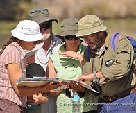

Find out why natural resource professionals and citizen scientists alike are using iMapInvasives to track invasive species.
Download the MapInvasives mobile app and learn about other ways that you can use iMapInvasives on your mobile devices.


Meet the people that make up the iMapInvasives Network and serve as adminstrators of the database in your state or province.